Next: 5.3 Driving rain models Up: 5. Measurements Previous: 5.1 Data processing and Contents
In the previous section 5.1, the data (sub)set of the full-scale measurements at the TUE site was defined by specifying the clock period and the quantities of interest. In this section, this data set, along with weather data from the weather station at Eindhoven Airport, is presented.
![\begin{center}%
%%% x-axis [cc][b]
\psfrag{maand} [cc][b]{ }
%%% y-axis [Bc]...
...h-measurements2/stat-c5/maand-gemidUh-c5_971201_991130_12.eps}%
\end{center}](img397.gif) |
Figure 5.2 shows monthly wind speed averages obtained
from measurements at the Auditorium and at the meteorological station
at Eindhoven Airport. For the airport wind speeds, 30-year normals and
the actual monthly averages were obtained from [KNMI 1997-99].
The figure also shows the averaged wind speed on top of the mast on the
Auditorium. These data are based on 5-min averages, and only wind
speeds of 0.1 m s![]() or more were taken into account. An asterisk in
the graph indicates that the monthly percentage of available clock
periods is below 80%. Inspection of figure 5.2
reveals that the actual monthly averages of wind speeds at Eindhoven
Airport and at the Auditorium are very similar; both data sets have
generally lower wind speeds than the 30-year normals. Since a
comparison of hourly averages is more informative than monthly
averages, this will be the subject of the following part of this
section 5.2.1.
or more were taken into account. An asterisk in
the graph indicates that the monthly percentage of available clock
periods is below 80%. Inspection of figure 5.2
reveals that the actual monthly averages of wind speeds at Eindhoven
Airport and at the Auditorium are very similar; both data sets have
generally lower wind speeds than the 30-year normals. Since a
comparison of hourly averages is more informative than monthly
averages, this will be the subject of the following part of this
section 5.2.1.
![% midden\{%
\small
%%% x-axis [cc][b]
\psfrag{UhEhv [m/s]} [cc][b]{$U_{\text...
...h/regres_Uh_EA_P1_PH_270_ch_971201_991130.eps}
\\
\end{tabbing}\par
%\}
\par](img398.gif) |
Figure 5.3 shows correlations of hourly wind speeds at
Eindhoven Airport
![]() and the Auditorium
and the Auditorium
![]() , selected for four wind direction intervals at
Eindhoven Airport (
, selected for four wind direction intervals at
Eindhoven Airport (
![]() ). The data for Eindhoven
Airport, published in [KNMI 2000], consists of hourly wind
speeds and hourly wind directions. The wind speeds published were
obtained by rounding off to 0.5 m s
). The data for Eindhoven
Airport, published in [KNMI 2000], consists of hourly wind
speeds and hourly wind directions. The wind speeds published were
obtained by rounding off to 0.5 m s![]() and subsequently by the
exposure correction to obtain
and subsequently by the
exposure correction to obtain ![]() at 10 m height on a
terrain with
at 10 m height on a
terrain with ![]() m ([Wieringa 1996] and
[Verkaik 2000]). This explains the vertical alignment of the
measurement points in figure 5.3. Only wind data with
m ([Wieringa 1996] and
[Verkaik 2000]). This explains the vertical alignment of the
measurement points in figure 5.3. Only wind data with
![]() m s
m s![]() are taken into account. The data of
the Auditorium are simply based on our measurements (uncorrected wind
speeds). The correlations in figures 5.3a, c and d (i.e.
for wind from the north, south and west) are similar:
are taken into account. The data of
the Auditorium are simply based on our measurements (uncorrected wind
speeds). The correlations in figures 5.3a, c and d (i.e.
for wind from the north, south and west) are similar:
![]() . This value is lower than
the value of 1.13 reported by [Geurts 1997]. He used 30-min
averages of the wind speeds which he measured at the Auditorium during
wind exceeding a predefined speed (5-8 m s
. This value is lower than
the value of 1.13 reported by [Geurts 1997]. He used 30-min
averages of the wind speeds which he measured at the Auditorium during
wind exceeding a predefined speed (5-8 m s![]() ) and he used wind
speed averages of the last 10 min of every clock hour at the Airport.
This difference between his and our data processing may explain the
difference in the values of
) and he used wind
speed averages of the last 10 min of every clock hour at the Airport.
This difference between his and our data processing may explain the
difference in the values of
![]() .
The statistics of this correlation is discussed in more detail by
[de Wit
et al. 2002].
.
The statistics of this correlation is discussed in more detail by
[de Wit
et al. 2002].
The correlation
![]() for eastern wind
is smaller (0.48, figure 5.3b). This is most likely due
to the position of the measurement point at the Auditorium (P1),
which is located west of the Main Building. The anemometer at P1
is measuring in the wake of the Main Building when wind is blowing
from the east. In the case of eastern wind, there is also an
influence of the town on the wind measurements at Eindhoven Airport
(located west of the town). However, the airport data were already
corrected to compensate for such influences.
for eastern wind
is smaller (0.48, figure 5.3b). This is most likely due
to the position of the measurement point at the Auditorium (P1),
which is located west of the Main Building. The anemometer at P1
is measuring in the wake of the Main Building when wind is blowing
from the east. In the case of eastern wind, there is also an
influence of the town on the wind measurements at Eindhoven Airport
(located west of the town). However, the airport data were already
corrected to compensate for such influences.
![\begin{center}%
%%% x-axis [cc][b]
\psfrag{Uhklas} [cc][b]{$U_{\text{h}}$ [m...
...urements2/stat-c5/Uhklas-P1-relcumsum-c5_971201_991130_12.eps}%
\end{center}](img405.gif) |
Finally, for illustrative purposes, the cumulative relative number
distribution of the 5-min wind speeds at the Auditorium is depicted in
figure 5.4. The mean wind speed for the whole
24 month period is 4.0 m s![]() (the standard deviation equals 1.9 m
s
(the standard deviation equals 1.9 m
s![]() ).
).
| horizontal rain amounts | dr. r. amounts | ||||
| year month | P2 | P3 | EA | P4/5 | P6 |
| 1997 12 | 64.5 | 57.8 | 53.1 | 2.78 | -- |
| 1998 01 | 67.7 | 62.8 | 58.2 | 5.77 | -- |
| 1998 02 | 12.9 | 11.8 | 10.8 | 0.83 | -- |
| 1998 03 | 85.2 | 76.3 | 80.3 | 4.87 | 5.25 |
| 1998 04 |
77.6 | 74.4 | 74.7 | 1.11 | 2.46 |
| 1998 05 | 32.5 | 21.5 | 26.5 | 0.94 | 2.03 |
| 1998 06 |
64.5 | 63.9 | 148.2 | 3.92 | 8.38 |
| 1998 07 | 56.2 | 54.8 | 50.3 | 1.93 | 2.75 |
| 1998 08 | 48.3 | 47.1 | 47.8 | 3.35 | 5.36 |
| 1998 09 | 131.8 | 132.6 | 167.7 | 9.61 | 14.21 |
| 1998 10 | 143.2 | 138.7 | 158.5 | 11.70 | 13.36 |
| 1998 11 | 80.1 | 75.4 | 80.4 | 0.59 | 1.17 |
| 1998 12 | 57.2 | 50.1 | 51.7 | 3.43 | 5.07 |
| 1999 01 | 85.8 | 79.1 | 102.6 | 3.30 | 6.20 |
| 1999 02 | 65.7 | 56.8 | 71.0 | 4.06 | 10.21 |
| 1999 03 | 73.1 | 66.4 | 68.2 | 4.31 | 5.74 |
| 1999 04 | 38.4 | 36.2 | 41.5 | 1.49 | 2.51 |
| 1999 05 | 53.4 | 52.8 | 71.6 | 0.12 | 0.52 |
| 1999 06 | 63.4 | 60.6 | 53.8 | 2.43 | 3.10 |
| 1999 07 | 46.9 | 44.2 | 68.8 | 2.25 | 4.54 |
| 1999 08 | 95.8 | 89.6 | 92.1 | 1.70 | 2.44 |
| 1999 09 | 29.8 | 25.6 | 38.0 | 0.76 | 1.23 |
| 1999 10 | 28.2 | 27.5 | 27.5 | 0.82 | 1.86 |
| 1999 11 | 34.2 | 35.6 | 43.2 | 0.80 | 1.72 |
| totals | 1536.6 | 1441.7 | 1686.5 | 72.90 | 100.13 |
Table 5.2 lists monthly precipitation amounts measured at Eindhoven Airport [KNMI 1997-99] and at the Auditorium. One should bear in mind that the precipitation data include rain, snow and other types of precipitation. However, according to the monthly weather reports [KNMI 1997-99], the monthly number of days with snowfall was approximately normal. (Normally, snow occurs during the months of November to April and the largest number of monthly snow days (8) occurs in February.) So, the monthly precipitation heights are often close to the actual rain amounts. Thirty-year normals of monthly rain amounts at Eindhoven Airport are not presented in the table, because the meteorological institute did not yet publish them. An asterisk in table 5.2 indicates that the number of available clock periods of the TUE data is below 80%. We recall here that horizontal rain is measured at two positions on the roof of the Auditorium, namely P2 and P3 (figure 3.4). Figure 5.5 depicts the monthly rain amounts measured at Eindhoven Airport and at position P2 on the Auditorium.
![\begin{center}%
%%% x-axis [cc][b]
\psfrag{maand} [cc][b]{ }
%%% y-axis [Bc]...
...]{h-measurements2/stat-c5/maand-somSh-c5_971201_991130_12.eps}%
\end{center}](img406.gif) |
Striking in the table and figure are the very large rain amounts measured in June, September and October 1998. Unfortunately, due to a 2-day malfunction of the data acquisition system in June 1998, a large amount of rain was not registered at the Auditorium. The high rainfall during September and October 1998 is considered in section 5.2.7, along with the corresponding wind and driving rain data. In general, the rain amounts measured at Eindhoven Airport and the Auditorium are in good agreement. There is no reason to consider systematic deviations due to topography, because the distance between these two measurement sites is not very large and the exposure of both sites is very open.
| horizontal rain | driving rain | number | ||||||||
|
|
P2 | P3 | P4/5 | P6 | all | rain | ||||
| [mm] | [%] | [mm] | [%] | [mm] | [%] | [mm] | [%] | [%] | [%] | |
|
0 |
49.9 | 3 | 47.5 | 3 | 0.01 | 0 | 0.06 | 0 | 5 | 2 |
|
30 |
38.2 | 2 | 37.4 | 3 | 0.00 | 0 | 0.00 | 0 | 7 | 1 |
|
60 |
20.0 | 1 | 18.8 | 1 | 0.00 | 0 | 0.00 | 0 | 7 | 2 |
|
90 |
13.2 | 1 | 12.9 | 1 | 0.00 | 0 | 0.00 | 0 | 3 | 1 |
|
120 |
51.5 | 3 | 50.7 | 4 | 0.00 | 0 | 0.00 | 0 | 5 | 3 |
|
150 |
73.9 | 5 | 71.3 | 5 | 0.00 | 0 | 0.00 | 0 | 4 | 5 |
|
180 |
157.4 | 10 | 154.2 | 11 | 0.11 | 0 | 0.11 | 0 | 10 | 12 |
|
210 |
403.6 | 26 | 363.9 | 25 | 11.47 | 16 | 8.31 | 8 | 21 | 30 |
|
240 |
311.3 | 20 | 289.8 | 20 | 24.22 | 33 | 23.41 | 23 | 18 | 21 |
|
270 |
229.3 | 15 | 212.5 | 15 | 29.04 | 40 | 44.83 | 45 | 10 | 13 |
|
300 |
108.1 | 7 | 103.8 | 7 | 6.16 | 8 | 17.24 | 17 | 6 | 6 |
|
330 |
77.5 | 5 | 76.1 | 5 | 1.86 | 3 | 6.15 | 6 | 4 | 4 |
|
|
||||||||||
|
m s |
2.8 | 0 | 2.7 | 0 | 0.02 | 0 | 0.02 | 0 | 0 | 0 |
| totals | 1536.6 | 100 | 1441.7 | 100 | 72.90 | 100 | 100.13 | 100 | 100 | 100 |
The distribution of 5-min horizontal rain amounts over twelve wind direction intervals
is listed in table 5.3. Clock periods with
![]() m
s
m
s![]() are listed separately. Obviously, most rain is coming with wind from
the south-west (
are listed separately. Obviously, most rain is coming with wind from
the south-west (![]() 225
225![]() ). The horizontal rain amount for wind
directions 195
). The horizontal rain amount for wind
directions 195![]() -255
-255![]() is approximately 45% of the total rain amount
over all wind directions, and occurs during approximately 50% of the total
5-min clock periods with rain. So, the average rain intensity for wind
directions 195
is approximately 45% of the total rain amount
over all wind directions, and occurs during approximately 50% of the total
5-min clock periods with rain. So, the average rain intensity for wind
directions 195![]() -255
-255![]() is only slightly lower than the rain intensity
averaged over all wind directions.
On the other hand, the average rain intensity for wind directions
15
is only slightly lower than the rain intensity
averaged over all wind directions.
On the other hand, the average rain intensity for wind directions
15![]() -115
-115![]() is almost equal to the overall average rain intensity.
is almost equal to the overall average rain intensity.
![\begin{center}%
%%% x-axis [cc][b]
\psfrag{Rhklas} [cc][b]{$R_{\text{h,c}}$ ...
...urements2/stat-c5/Rhklas-P2-relcumsum-c5_971201_991130_12.eps}%
\end{center}](img408.gif) |
Figure 5.6 shows two distributions of horizontal rain
intensities measured at the Auditorium during the 24-month measuring period.
One distribution (the solid line) is the cumulative relative distribution of the
number of 5-min clock periods with a particular rain intensity. The other
distribution (the dashed line in the figure) is the cumulative relative
distribution of the rain amount contributed by all clock periods with a
particular rain intensity. The dashed line increases less with the horizontal
rain intensity than the solid line, because there are less clock periods with a
high rain intensity than with a low rain intensity and because clock periods
with a high rain intensity contribute more to the total rain amount than clock
periods with a low rain intensity. The cumulative relative distribution in
terms of the rain amount (dashed line) is hence more useful. The median
indicated in the figure represents the rain intensity below which half of all
rain water is collected. At position P2 on the Auditorium the median 5-min
rain intensity is 2.2 mm h![]() .
.
![\begin{center}%
%%% x-axis [cc][b]
\psfrag{Sh} [cc][b]{1-day rain amount [mm]...
.../stat-c5/onedaysums-P2-c5_199712-199802-199812-199902-bis.eps}%
\end{center}](img409.gif) |
Figure 5.7 shows the relative number distribution of daily amounts
of horizontal rain at De Bilt presented by []p. 93]buishand:1980, and at
the Auditorium (P2). The data of De Bilt were taken from winters from 1906
to 1977. Therefore the TUE data were taken from the winter months December 1997
to February 1998 and December 1998 to February 1999. The data of
[Buishand and
Velds 1980] do not indicate zero daily amounts separately: so
approximately 60% of the days had a daily amount of less than 1 mm. Our data
show that approximately 40% of the days had no rain and approximately 20%
had a rain amount between 0 and 1 mm. Apart from this possible difference, the
figure shows quite a good agreement between the TUE rain data and the De Bilt
rain data. We cannot state whether this agreement is fortuitous or not,
because similar data for the weather station at Eindhoven Airport for a period
of many years (![]() 30 years) have not yet been published.
30 years) have not yet been published.
![\begin{center}%
%%% x-axis [cc][b]
\psfrag{relV} [cc][b]{$ 2 ( R_{\text{h,c,\...
...ments2/stat-c5/relsomSh-relV-P2P3-c5_971201_991130_12_nul.eps}%
\end{center}](img411.gif) |
On the roof of the Auditorium two tipping-bucket rain gauges were installed at
positions P2 and P3, respectively (figure 3.4). The
distance between these two positions is 33 m. The purpose of the two rain
gauges is to investigate spatial differences in rain intensity on the roof.
Figure 5.8 shows the horizontal rain amounts measured at
P2 and P3 (normalised to the total rain amount) corresponding to
relative differences of the rain intensity measured by the two gauges. These
relative differences are defined as the difference in rain intensity
divided by the mean rain intensity:
From the figure one can deduce that the rain intensity difference is within 10% (30%) for approximately 52% (83%) of the total rain amount. These results are quite satisfactory, form which we conclude that the two positions P2 and P3 represent the same situation.
![\begin{center}%
%%% x-axis [cc][b]
\psfrag{dag} [cc][b]{ }
%%% y-axis [Bc][t...
...t-c5-parsivel/dag-Sh-P2P3parsivel-c5_991001_000131_12_nul.eps}%
\end{center}](img413.gif) |
![\begin{center}%
%%% x-axis [cc][b]
\psfrag{relV} [cc][b]{$ 2 (R_{\text{h,c,\t...
...parsivel/relsomSh-relV-P2Parsivel-c5_991001_000131_12_nul.eps}%
\end{center}](img414.gif) |
At approximately 1.5 m from the rain gauge at position P3 a disdrometer was installed. The disdrometer was operational from 1-10-1999 to 7-1-2000. Figure 5.9 presents the cumulative horizontal rain amounts measured by the three devices during this period. Differences are within 30% on monthly basis. Remarkably, the amounts collected by the disdrometer seem larger than those collected by the two rain gauges.
A distribution of rain amounts over intervals of relative differences
(cf. formula 5.2) between the gauge at P2 and
the disdrometer for every 5-min clock period is plotted in figure
5.10. Almost 18% (46%) of the total
horizontal rain amount is measured with less than 10% (30%)
difference between the 5-min values of the rain gauge and the
disdrometer. The figure also shows that the disdrometer measures
quite a large rain amount during clock periods when the rain gauge
measures no rain (i.e. when the relative difference equals ![]() ). This
explains figure 5.9, where we observed that
the total amount of rain measured by the disdrometer is larger than
the total amount of rain measured by the rain gauges. The implications
of this observation are not clear, because the considered period
comprises only almost three months (during which disdrometer data are
missing from 12-20 December 1999) and because we do not have much
experience with the disdrometer. It is possible that the disdrometer
does not function totally well and its performance should be
investigated in more detail.
). This
explains figure 5.9, where we observed that
the total amount of rain measured by the disdrometer is larger than
the total amount of rain measured by the rain gauges. The implications
of this observation are not clear, because the considered period
comprises only almost three months (during which disdrometer data are
missing from 12-20 December 1999) and because we do not have much
experience with the disdrometer. It is possible that the disdrometer
does not function totally well and its performance should be
investigated in more detail.
Nevertheless, we conclude that the differences in reading between the rain gauge and the disdrometer are generally not so bad, because, as said before, the rain intensity difference is within 30% for approximately 46% of the total rain amount.
A rain spell is defined here as a period consisting of consecutive
5-min clock periods with
![]() mm h
mm h![]() . In figure
5.11, the cumulative relative distribution of rain
spell durations measured at the Auditorium is plotted. Almost 50% of
the rain spells take less than 25 min. In section
5.1, we noted that hourly rain
intensity data should be applied with care, because they will give a
poor indication of actual rain intensities, especially
maxima. Figure 5.11 supports for this
conclusion: rain spells are often shorter than an hour.
. In figure
5.11, the cumulative relative distribution of rain
spell durations measured at the Auditorium is plotted. Almost 50% of
the rain spells take less than 25 min. In section
5.1, we noted that hourly rain
intensity data should be applied with care, because they will give a
poor indication of actual rain intensities, especially
maxima. Figure 5.11 supports for this
conclusion: rain spells are often shorter than an hour.
![\begin{center}%
%%% x-axis [cc][b]
\psfrag{tklas[1min]} [cc][b]{rain spell du...
...h-measurements2/stat-c5/tklas-cumsumN-c5_971201_991130_12.eps}%
\end{center}](img417.gif) |
From our measurements, we can also calculate the percentage of the time that rain occurs. This is approximately 8%. [Buishand and Velds 1980] mention a percentage of 7% for the Netherlands.
Driving rain measurements were performed by two TUE-II type gauges. One of these gauges was placed at a central position on the west façade of the Main Building (positions P4 or P5; in short: P4/5), and the other TUE-II gauge was installed at the north edge of the façade (position P6). The reader is referred to figure 3.6 for a drawing of the exact positions.
Figure 5.12 shows the monthly driving rain amounts collected by the driving rain gauges at P4/5 and P6, respectively. The same information is listed in table 5.2. The driving rain gauge at the edge (P6) catches 1.1 to 4.3 times the driving rain amount of the central gauge (P4/5), and on average about 1.5 times as much.
![\begin{center}%
%%% x-axis [cc][b]
\psfrag{maand} [cc][b]{ }
%%% y-axis [Bc]...
...{h-measurements2/stat-c5/maand-somSf-P45-P6-971201_991130.eps}%
\end{center}](img418.gif) |
![\begin{center}%
a.
%%% x-axis [cc][b]
\psfrag{Uh} [cc][b]{$U_{\text{h}}$ [m...
...e]{h-measurements2/stat-c5/SfP6-Uh-PH-c5_971201_991130_12.eps}%
\end{center}](img419.gif) |
![% midden\{%
\small
%%% x-axis [cc][b]
\psfrag{Uy [m/s]} [cc][b]{$-U_{\text{y...
...t-c5/Uy-Rf-P6_c5_971201_991130_12_Rh40_41.eps}
\\
\end{tabbing}\par
%\}
\par](img420.gif) |
Figure 5.13a gives a distribution of driving rain
measured by the TUE-II gauge at position P4/5 from December
1997 to November 1999, over intervals of reference wind speed and wind
direction measured at the top of the mast on the Auditorium. Figure
5.13b shows the driving rain distribution for the
north-edge west façade position P6.
The edge catches especially more rain for wind speeds between 3 and
10 m s![]() and for wind directions of NW and W.
and for wind directions of NW and W.
Figure 5.14 shows 5-min driving rain intensities as a function of the
wind velocity component perpendicular to the façade (![]() ) for two narrow
horizontal rain intensity intervals (
) for two narrow
horizontal rain intensity intervals (
![]() ) and for the two
positions P4/5 and P6. Note that the
) and for the two
positions P4/5 and P6. Note that the ![]() axis of the graphs represents
axis of the graphs represents
![]() (with the minus) because only negative values of
(with the minus) because only negative values of ![]() correspond to wind
blowing towards the façade (see the axis definition in figures
2.4 and 3.4). As we expect, driving rain
intensity increases with wind speed and horizontal rain intensity. However, one
also concludes from these plots that driving rain intensities even show large
variations for a particular wind speed and horizontal rain intensity. A factor
which has not been measured and therefore is not taken into account here, is the
raindrop spectrum. Variations of the raindrop spectrum might be the cause of a
part of the variation in driving rain intensities. In section
5.3 the relation between wind speed, wind direction,
horizontal rain intensity and driving rain intensity will be described in more
detail.
correspond to wind
blowing towards the façade (see the axis definition in figures
2.4 and 3.4). As we expect, driving rain
intensity increases with wind speed and horizontal rain intensity. However, one
also concludes from these plots that driving rain intensities even show large
variations for a particular wind speed and horizontal rain intensity. A factor
which has not been measured and therefore is not taken into account here, is the
raindrop spectrum. Variations of the raindrop spectrum might be the cause of a
part of the variation in driving rain intensities. In section
5.3 the relation between wind speed, wind direction,
horizontal rain intensity and driving rain intensity will be described in more
detail.
![\begin{center}%
a.
%%% x-axis [cc][b]
\psfrag{Rfklas} [cc][b]{$R_{\text{f}}$...
...urements2/stat-c5/Rfklas-P6-relcumsum-c5_971201_991130_12.eps}%
\end{center}](img422.gif) |
Distributions of driving rain intensities are drawn in figures
5.15a for P4/5 and
5.15b for P6. Every figure has two lines and is
similar to figure 5.6 (for horizontal rain). The solid
line represents the cumulative relative distribution of 5-min clock periods with
a particular driving rain intensity. The dashed line represents the cumulative
relative distribution of the total driving rain amount contributed by all clock
periods with a particular rain intensity.
The medians at positions P4/5 and P6 are 0.67 and 1.0 mm h![]() ,
respectively. This suggests that the driving rain intensities at the façade
edge (P6) are higher than at the central façade position (P4/5).
The discussion on the differences between the two façade positions is
continued in the following section.
,
respectively. This suggests that the driving rain intensities at the façade
edge (P6) are higher than at the central façade position (P4/5).
The discussion on the differences between the two façade positions is
continued in the following section.
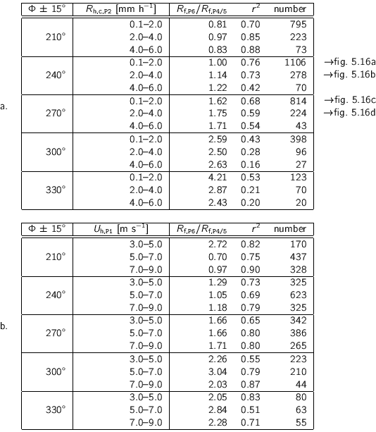
Table 5.4 lists the results of least-squares fits (![]() ) of
correlations between the driving rain intensities measured at P4/5 and
P6, respectively. The correlations are obtained from the data selected
according to various wind direction intervals and horizontal rain intensity
intervals (table 5.4a) and according to various wind direction
intervals and wind speed intervals (table 5.4b). The intervals
cannot be taken too small, because in that case the number of data points would
be too low. For this reason, the data are not selected by the three parameters
(wind direction, wind speed and rain intensity) together. Correlations with a
selection based on the horizontal rain intensity and the wind speed component
perpendicular to the façade (
) of
correlations between the driving rain intensities measured at P4/5 and
P6, respectively. The correlations are obtained from the data selected
according to various wind direction intervals and horizontal rain intensity
intervals (table 5.4a) and according to various wind direction
intervals and wind speed intervals (table 5.4b). The intervals
cannot be taken too small, because in that case the number of data points would
be too low. For this reason, the data are not selected by the three parameters
(wind direction, wind speed and rain intensity) together. Correlations with a
selection based on the horizontal rain intensity and the wind speed component
perpendicular to the façade (![]() ) are not shown here, because these lead
to very dispersed correlation plots.
) are not shown here, because these lead
to very dispersed correlation plots.
|
|
![% midden\{%
\small
%%% x-axis [cc][b]
\psfrag{Rf P45 [mm/h]} [cc][b]{$R_{\te...
...201_991130_12_Sh_20_40_Uh_0_50_Ph_255_285.eps}
\\
\end{tabbing}\par
%\}
\par](img424.gif) |
Four correlations of table 5.4a are plotted in figure
5.16. From the figure and table 5.4a, one
concludes that south-western wind (i.e. between 210![]() and 240
and 240![]() ) yields
a ratio
) yields
a ratio
![]() of approximately 1, and this
ratio increases for western and north-western winds. The coefficient of
determination (
of approximately 1, and this
ratio increases for western and north-western winds. The coefficient of
determination (![]() ) is worse for wind directions of 330
) is worse for wind directions of 330![]() than for wind
directions of 210
than for wind
directions of 210![]() or 240
or 240![]() . This is mainly due to a low number of
data points, and perhaps also due to more variation caused by the turbulence at
the façade edge near P6. Table 5.4a also shows that,
generally, an increase of the horizontal rain intensity for a particular wind
direction interval does not change the ratio
. This is mainly due to a low number of
data points, and perhaps also due to more variation caused by the turbulence at
the façade edge near P6. Table 5.4a also shows that,
generally, an increase of the horizontal rain intensity for a particular wind
direction interval does not change the ratio
![]() much. At the wind direction
interval of 330
much. At the wind direction
interval of 330![]() the ratios are different for lower and higher rain
intensities; this is due to the large scatter (and the small number of data) at
the higher rain intensities. Table 5.4b lists the correlations
of
the ratios are different for lower and higher rain
intensities; this is due to the large scatter (and the small number of data) at
the higher rain intensities. Table 5.4b lists the correlations
of
![]() for various wind direction
intervals and wind speed intervals. The ratios reveal no particular tendency
for increasing wind speeds. Our data indicate that the wind direction has a
much larger influence on the ratio, than wind speed and horizontal rain
intensity.
for various wind direction
intervals and wind speed intervals. The ratios reveal no particular tendency
for increasing wind speeds. Our data indicate that the wind direction has a
much larger influence on the ratio, than wind speed and horizontal rain
intensity.
The year 1998 was an extremely wet year, so even the 1998 annual report of the KNMI was dedicated to rain [KNMI 1999]. The rain amounts of March, April, June, September, October and December 1998 were almost twice of the normal rain amounts. The yearly total was 1239.6 mm (normally 803 mm). At Eindhoven Airport the yearly total was 955.1 mm. At the Auditorium we measured 857.2 mm at P2 and 809.4 mm at P3. The Auditorium total is approximately 100 to 150 mm less than the Airport total, of which approximately 80 mm can be attributed to the malfunction of our devices during June 1998.
We measured a series of high driving rain intensities in September 1998 and October 1998. The driving rain gauge at P4/5 collected 6.1 mm of driving rain during 20 hours continuously on 14 and 15 September 1998 (the monthly driving rain amount was 8.5 mm). The reservoir of the driving rain gauge was emptied once during rain; this may have led to an error of 0.1 mm. Also much of the driving rain amount in October 1998 was collected in a short time. During 20 h on 27 and 28 October 1998 the gauge at P4/5 measured 6.0 mm. Unfortunately, the reservoir had to be emptied twice during rain, which may have led to an error of 0.4 mm. The total driving rain amount of October 1998 was 10.3 mm. Note that these mentioned errors relate to the exceptional cases in September and October 1998, when the reservoirs were (almost) overflowed. Of course, these errors are not typical for the normal functioning of the driving rain gauges.
![\begin{center}%
\small
%%% x-axis [cc][b]
\psfrag{kloktijd [h]} [cc][b]{hour...
...ments2/stat-c5/detail-somregen-P2-P45-P6-c5_981028_981030.eps}
\end{center}](img426.gif) |
![\begin{center}%
\small
%%% x-axis [cc][b]
\psfrag{kloktijd [h]} [cc][b]{hour...
...measurements2/stat-c5/detail-R-P2-P45-P6-c5_981028_981030.eps}
\end{center}](img427.gif) |
For merely illustrative purposes, figures
5.17-5.19 show the wind speeds, wind
directions, horizontal rain and driving rain (intensities as well as
cumulative amounts) measured on 28-10-1998 and 29-10-1998. Remarkable
for the presented rain events is that a sudden wind direction change
towards 270![]() goes along with increasing horizontal rain and
driving rain intensities, which reach very high peek values at
28-10-1998 on 10h25 and 29-10-1998 on 05h15. The dynamics of the
horizontal rain and the driving rain were so high that the lower rain
intensities in figure 5.19 are hardly visible.
goes along with increasing horizontal rain and
driving rain intensities, which reach very high peek values at
28-10-1998 on 10h25 and 29-10-1998 on 05h15. The dynamics of the
horizontal rain and the driving rain were so high that the lower rain
intensities in figure 5.19 are hardly visible.
Tables 5.5 and 5.6 list the ten 5-min clock periods with the highest driving rain intensities measured at position P4/5 and P6, respectively. The tables also list the horizontal rain intensities, wind speeds, wind directions and dates corresponding to the ten largest driving rain intensities. For every value of a quantity, except for the wind direction, its rank and its number of occurrence is indicated. A rank of 1 means that the value is the highest value. To avoid many ranking levels, the quantities were rounded to a tenth or to one. If the number of occurrence of a particular value is more than one, this means that the same value occurred several times. If the number of occurrence of a driving rain intensity value is more than one, the indicated date is the date of the first occurrence. The indicated dates (and times) give the start of the 5-min clock periods.
|
|
29.3 | 17.8 | 15.7 | 13.0 | 10.5 | 9.6 | 7.2 | 6.7 | 6.4 | 6.0 |
| rank | 1 | 2 | 3 | 4 | 5 | 6 | 7 | 8 | 9 | 10 |
| # | 1 | 1 | 1 | 1 | 1 | 1 | 1 | 2 | 1 | 1 |
|
|
- | - | 24.9 | 17.5 | 9.9 | 16.5 | 8.6 | - | 10.3 | 4.9 |
| rank | - | - | 1 | 2 | 6 | 3 | 10 | - | 5 | 22 |
| # | - | - | 1 | 1 | 1 | 1 | 1 | - | 1 | 1 |
|
|
46 | 31 | 31 | 41 | 45 | 28 | 50 | 33 | 22 | 34 |
| rank | 4 | 13 | 13 | 7 | 5 | 15 | 3 | 11 | 18 | 10 |
| # | 1 | 3 | 3 | 1 | 1 | 1 | 1 | 2 | 1 | 1 |
|
|
53 | 29 | 30 | 40 | 48 | 27 | 50 | 30 | 20 | 25 |
| rank | 2 | 11 | 10 | 7 | 4 | 13 | 3 | 10 | 18 | 15 |
| # | 2 | 1 | 3 | 1 | 1 | 1 | 1 | 3 | 3 | 1 |
|
|
11.1 | 1.9 | 9.3 | 6.2 | 5.9 | 9.7 | 7.6 | 9.5 | 4.8 | 5.7 |
| rank | 47 | 139 | 65 | 96 | 99 | 61 | 82 | 63 | 110 | 101 |
| # | 43 | 2691 | 192 | 1600 | 1930 | 175 | 666 | 185 | 3184 | 2160 |
|
|
269 | 245 | 278 | 260 | 253 | 263 | 221 | 208 | 256 | 223 |
|
|
11.1 | 1.7 | 9.3 | 6.1 | 5.7 | 9.7 | 4.9 | 4.5 | 4.7 | 3.9 |
| rank | 26 | 120 | 44 | 76 | 80 | 40 | 88 | 92 | 90 | 98 |
| # | 12 | 2778 | 61 | 498 | 684 | 52 | 1238 | 1458 | 1382 | 2084 |
| year | 1998 | 1998 | 1998 | 1998 | 1998 | 1998 | 1999 | 1998 | 1999 | 1999 |
| month | 10 | 1 | 10 | 9 | 8 | 6 | 6 | 1 | 2 | 8 |
| day | 28 | 7 | 29 | 9 | 26 | 2 | 3 | 3 | 21 | 18 |
| hour | 10 | 14 | 5 | 16 | 14 | 15 | 21 | 15 | 17 | 11 |
| minute | 30 | 0 | 15 | 55 | 35 | 55 | 55 | 25 | 40 | 20 |
|
|
15.7 | 13.0 | 9.6 | 3.8 | 6.4 | 10.5 | 3.8 | 4.2 | 3.7 | 7.2 |
| rank | 3 | 4 | 6 | 18 | 9 | 5 | 18 | 15 | 19 | 7 |
| # | 1 | 1 | 1 | 2 | 1 | 1 | 2 | 2 | 1 | 1 |
|
|
24.9 | 17.5 | 16.5 | 12.6 | 10.3 | 9.9 | 9.6 | 9.4 | 9.3 | 8.6 |
| rank | 1 | 2 | 3 | 4 | 5 | 6 | 7 | 8 | 9 | 10 |
| # | 1 | 1 | 1 | 1 | 1 | 1 | 1 | 1 | 1 | 1 |
|
|
31 | 41 | 28 | 19 | 22 | 45 | 17 | 59 | 20 | 50 |
| rank | 13 | 7 | 15 | 21 | 18 | 5 | 23 | 1 | 20 | 3 |
| # | 3 | 1 | 1 | 3 | 1 | 1 | 6 | 1 | 7 | 1 |
|
|
30 | 40 | 27 | 18 | 20 | 48 | 17 | 58 | 18 | 50 |
| rank | 10 | 7 | 13 | 20 | 18 | 4 | 21 | 1 | 20 | 3 |
| # | 3 | 1 | 1 | 5 | 3 | 1 | 6 | 1 | 5 | 1 |
|
|
9.3 | 6.2 | 9.7 | 7.7 | 4.8 | 5.9 | 6.6 | 1.7 | 7.3 | 7.6 |
| rank | 65 | 96 | 61 | 81 | 110 | 99 | 92 | 141 | 85 | 82 |
| # | 192 | 1600 | 175 | 598 | 3184 | 1930 | 1291 | 2431 | 824 | 666 |
|
|
278 | 260 | 263 | 283 | 256 | 253 | 292 | 262 | 294 | 221 |
|
|
9.3 | 6.1 | 9.7 | 7.5 | 4.7 | 5.7 | 6.2 | 1.7 | 6.7 | 4.9 |
| rank | 44 | 76 | 40 | 62 | 90 | 80 | 75 | 120 | 70 | 88 |
| # | 61 | 498 | 52 | 225 | 1382 | 684 | 489 | 2778 | 369 | 1238 |
| year | 1998 | 1998 | 1998 | 1998 | 1999 | 1998 | 1998 | 1999 | 1998 | 1999 |
| month | 10 | 9 | 6 | 10 | 2 | 8 | 8 | 7 | 8 | 6 |
| day | 29 | 9 | 2 | 28 | 21 | 26 | 22 | 4 | 24 | 3 |
| hour | 5 | 16 | 15 | 10 | 17 | 14 | 14 | 23 | 1 | 21 |
| minute | 15 | 55 | 55 | 25 | 40 | 35 | 50 | 30 | 40 | 55 |
The ten largest 5-min driving rain intensities at P4/5 are all
unique occurrences (except for the 8th in rank, which occurred twice),
and range from 6.0 to 29.3 mm h![]() . The corresponding horizontal
rain intensities range from 22 to 53 mm h
. The corresponding horizontal
rain intensities range from 22 to 53 mm h![]() , and are very high
compared to the median of 2.2 mm h
, and are very high
compared to the median of 2.2 mm h![]() (see figure
5.6). The corresponding wind speeds range from
1.7 (!) to 11.1 m s
(see figure
5.6). The corresponding wind speeds range from
1.7 (!) to 11.1 m s![]() . One would expect that higher wind speeds
and horizontal rain intensities would yield higher driving rain
intensities, but this is not obvious for the events in table
5.5. Only the values of the wind speed components
perpendicular to the façade (
. One would expect that higher wind speeds
and horizontal rain intensities would yield higher driving rain
intensities, but this is not obvious for the events in table
5.5. Only the values of the wind speed components
perpendicular to the façade (![]() ) show a more distinct increasing
tendency. Remarkable is that the second highest driving rain intensity
occurred when the wind speed was only 1.9 m s
) show a more distinct increasing
tendency. Remarkable is that the second highest driving rain intensity
occurred when the wind speed was only 1.9 m s![]() . A close inspection
of the data of 7-1-1998 14h00 reveals that the previous clock period
had a wind speed
. A close inspection
of the data of 7-1-1998 14h00 reveals that the previous clock period
had a wind speed ![]() of 5.9 m s
of 5.9 m s![]() and a rain intensity of 1.2 mm
h
and a rain intensity of 1.2 mm
h![]() . The next clock period had a wind speed
. The next clock period had a wind speed ![]() of 8.5 m s
of 8.5 m s![]() and a rain intensity of 7.8 mm h
and a rain intensity of 7.8 mm h![]() . It is therefore possible that the wind speed
indicated in the table for 7-1-1998 14h00-14h05 is an error due to a time
lag between the clocks in the two data acquisition systems (one
for the rain measurements, the other for the wind measurements, see
figure 3.19).
. It is therefore possible that the wind speed
indicated in the table for 7-1-1998 14h00-14h05 is an error due to a time
lag between the clocks in the two data acquisition systems (one
for the rain measurements, the other for the wind measurements, see
figure 3.19).
Table 5.5 also shows driving rain intensities at P6 corresponding to the ten highest driving rain intensities at P4/5. Note that the driving rain gauge at P6 was not operational at the time of the 5-min clock periods starting at 7-1-1998 14h00 and 3-1-1998 15h25. At 28-10-1998 10h30 the reservoir of the P6 driving rain gauge was emptied to prevent it from overflowing and thus the actual driving rain intensity at P6 could not be registered.
Table 5.6 shows the 10 highest driving rain intensities measured at position P6. The 10 highest driving rain intensities at P6 correspond to the 20 highest driving rain intensities at P4/5 (see the ranks in the second row in table 5.6). Similar to P4/5, one can conclude that the circumstances for very high driving rain intensities at P6 vary quite a lot and there is no evident correlation between the wind speed, the horizontal rain intensity and the driving rain intensity. Note that a two year measurement period is too short for decisive conclusions with respect to rain events with extreme driving rain, although the measurements were carried out during an extremely wet year. Nevertheless, the driving rain intensity values of tables 5.5 and 5.6 can be used as a guide for driving rain gauge design (cf. section 4.4).
As was mentioned in section 5.2.3, the disdrometer was only operational from 1-10-1999 to 7-1-2000. Although this is a rather short period and only a small part coincides with the general 24-month measurement period, some (exemplary) results are presented here to demonstrate the temporal variability and the parameterisation of raindrop spectra. Table 5.7 lists the horizontal and driving rain amounts measured during the period when the disdrometer was operational. It shows that the driving rain amounts during this period were small.
| hor. rain | dr. rain | |||||
|
|
P2 | P3 | disdro | P4/5 | P6 | number |
|
0 |
4.2 | 3.9 | 4.9 | 0.00 | 0.01 | 187 |
|
30 |
0.0 | 0.0 | 0.6 | 0.00 | 0.00 | 151 |
|
60 |
0.0 | 0.0 | 1.3 | 0.00 | 0.00 | 404 |
|
90 |
0.0 | 0.0 | 0.5 | 0.00 | 0.00 | 210 |
|
120 |
1.8 | 1.8 | 2.8 | 0.00 | 0.00 | 167 |
|
150 |
1.3 | 1.1 | 1.9 | 0.00 | 0.00 | 142 |
|
180 |
4.9 | 4.9 | 6.5 | 0.00 | 0.00 | 382 |
|
210 |
28.6 | 29.6 | 31.3 | 0.33 | 0.33 | 1488 |
|
240 |
20.0 | 20.5 | 24.8 | 1.25 | 1.60 | 1224 |
|
270 |
13.0 | 12.8 | 17.3 | 2.06 | 4.25 | 491 |
|
300 |
5.2 | 5.5 | 6.1 | 0.32 | 1.15 | 214 |
|
330 |
2.5 | 2.8 | 3.0 | 0.00 | 0.05 | 188 |
|
|
0.8 | 0.7 | 0.1 | 0.02 | 0.01 | 27 |
| totals | 82.2 | 83.5 | 101.0 | 3.97 | 7.38 | 5275 |
Figure 5.20 shows the measured horizontal raindrop mass flux spectra of an arbitrarily chosen period of rain. The plotted sequential 10-min spectra show the evolution of a rain period with its large changes of raindrop spectra and rain intensity.
In chapter 6 we will use the raindrop
spectrum parameterisation of [Wessels 1972]. He obtained a
range of the parameter ![]() of the [Best 1950] spectrum formula
(eq. 2.24). Ninety percent of his 533 observations at De Bilt
(NL) had a value of
of the [Best 1950] spectrum formula
(eq. 2.24). Ninety percent of his 533 observations at De Bilt
(NL) had a value of ![]() ranging from 0.88 to 1.77. Here, we compare
raindrop spectra measured with our disdrometer with raindrop spectra
calculated with
ranging from 0.88 to 1.77. Here, we compare
raindrop spectra measured with our disdrometer with raindrop spectra
calculated with ![]() and
and ![]() . The calculated raindrop spectra
have the same horizontal rain intensity as the measured spectra. The
purpose is to investigate how much the calculated spectra differ from
actual spectra. Figure 5.21c shows a raindrop
spectrum measured by the disdrometer during an arbitrary 5-min clock
period. The asterisk indicates the median drop size. Figures
5.21a and 5.21b
show the corresponding raindrop spectra calculated with
. The calculated raindrop spectra
have the same horizontal rain intensity as the measured spectra. The
purpose is to investigate how much the calculated spectra differ from
actual spectra. Figure 5.21c shows a raindrop
spectrum measured by the disdrometer during an arbitrary 5-min clock
period. The asterisk indicates the median drop size. Figures
5.21a and 5.21b
show the corresponding raindrop spectra calculated with ![]() and
1.77, respectively. They are obviously different from the measured spectrum.
and
1.77, respectively. They are obviously different from the measured spectrum.
![\begin{center}%
%%% x-axis [cc][b]
\psfrag{D} [cc][b]{$D$ [mm]}
%%% y-axis ...
...-parsivel-wessels-13-19-c5_991001_000131_12_35_112_270_15.eps}%
\end{center}](img431.gif) |
![\begin{center}%
%%% x-axis [cc][b]
\psfrag{D50 parsivel [mm]} [cc][b]{$D_{50,...
...am/D50-parsivel-wessels-c5_991001_000131_12_35_112_270_15.eps}%
\end{center}](img432.gif) |
Figure 5.22 shows the correlation between the
median drop size of the measured spectra (
![]() ) and
the median drop sizes of the two calculated raindrop spectra (with
) and
the median drop sizes of the two calculated raindrop spectra (with
![]() ,
,
![]() , and 1.77,
, and 1.77,
![]() ). The median
drop size was chosen to make differences in the spectra visible (yet to
some extent). Figure 5.22 shows that generally
the measured median drop size is between the two calculated median drop
sizes (i.e. the straight line is between a
). The median
drop size was chosen to make differences in the spectra visible (yet to
some extent). Figure 5.22 shows that generally
the measured median drop size is between the two calculated median drop
sizes (i.e. the straight line is between a
![]() and a
and a
![]() at
the same
at
the same
![]() ). However, for larger median drop
sizes the measured median drop size becomes larger than the calculated
median drop sizes. This indicates that the measured drop spectra
contain more larger drops than the spectra calculated with the given
parameters (cf. figure 5.21). From the figure
we conclude that the measured raindrop spectra come close to the two
parameterisations of [Wessels 1972], but that the
parameterisations have a tendency to underestimate the number of large
drops. [Schönhuber et al. 2000] measured raindrop spectra of a few
storm events in a moderate climate with a two-dimensional
video-disdrometer. These few measurements revealed a considerable number
of large drops up to 8 mm (more than one expects from the
[Marshall and
Palmer 1948] spectra) and seem to support our suggestion that the
number of large drops is underestimated by relations like those of
[Marshall and
Palmer 1948] and [Best 1950].
). However, for larger median drop
sizes the measured median drop size becomes larger than the calculated
median drop sizes. This indicates that the measured drop spectra
contain more larger drops than the spectra calculated with the given
parameters (cf. figure 5.21). From the figure
we conclude that the measured raindrop spectra come close to the two
parameterisations of [Wessels 1972], but that the
parameterisations have a tendency to underestimate the number of large
drops. [Schönhuber et al. 2000] measured raindrop spectra of a few
storm events in a moderate climate with a two-dimensional
video-disdrometer. These few measurements revealed a considerable number
of large drops up to 8 mm (more than one expects from the
[Marshall and
Palmer 1948] spectra) and seem to support our suggestion that the
number of large drops is underestimated by relations like those of
[Marshall and
Palmer 1948] and [Best 1950].
© 2002 Fabien J.R. van Mook
![\begin{center}%
\small
%%% x-axis [cc][b]
\psfrag{kloktijd [h]} [cc][b]{hour...
...te]{h-measurements2/stat-c5/detail-Uh-PH-c5_981028_981030.eps}
\end{center}](img425.gif)
![\begin{center}%
%%% x-axis [cc][b]
\psfrag{D} [cc][b]{$D$ [mm]}
\psfrag{ti...
...tat-parsivel2/D-t-fih-c10_991001_000131_6_1999-10-02T1300.eps}%
\end{center}](img430.gif)